search
Santa croce Venice map
Map of santa croce Venice. Santa croce Venice map (Italy) to print. Santa croce Venice map (Italy) to download. Santa Croce is one of the six sestieri of Venice, northern Italy as its shown in santa croce Venice map. Santa croce Venice occupies the north west part of the main islands, and can be divided into two areas: the eastern area being largely mediaeval, and the western - including the main port and the Tronchetto - mostly lying on land reclaimed in the 10th century. The area of santa croce Venice was once part of the Luprio swamp, but has been steadily reclaimed. It is the area most affected by the opening of the lagoon road in April 1933.
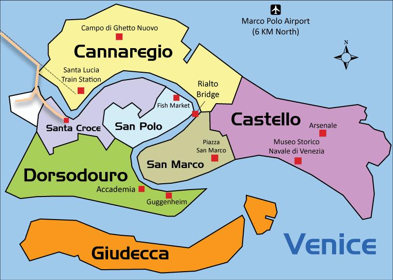
The district of santa croce Venice includes the Piazzale Roma, home to Venice bus station and car parks, and around which is the only area of the city in which cars can travel as you can see in santa croce Venice map. The tourist attractions in santa croce Venice lie mostly in the eastern part of the quarter, and include the Church of San Nicolo da Tolentino, the Fondaco dei Turchi, the Church of San Giacomo dell'Orio, the Centre for the History of Costume, the Patrician Palace and Ca'Corner della Regina.